 GEOLocate Standalone Desktop Application (version 3.xx)
Features | Frequently Asked Questions | Updates | Downloads
 GEOLocate is a comprehensive electronic georeferencing solution
funded by the National Science Foundations and developed by Tulane University's
Museum of Natural History designed to facilitate the task of assigning geographic
coordinates to specimen locality data associated with natural history collections.
It is similar to how google maps helps find your house or the nearest Starbucks,
but instead of deciphering addresses, GEOLocate analyzes specimen locality descriptions.
Unlike addresses, locality description of specimen collections are quite varied
and oftentimes difficult to pinpoint. Therefore, GEOLocate also provides an interface
to visualize and correct as nessesary the results of automated georeferencing.
Georeferencing allows data from previous collection events to be displayed on digital maps, permitting researchers to visualize the spatial and temporal intensity of scientific collecting activity, examine species distributions, and develop predictive models of species habitat use. It also allows researchers to use natural history data to address important scientific and societal needs such as conservation, environmental restoration, and preparing for global climate change.
It is estimated that there are nearly 3 billion specimens in Natural History Museums worldwide, the vast majority of which, lack geographic coordinates, underscoring the importance of automated tools for georeferencing.
Verison 3.xx is the original standalone desktop application.
Features
- Import of existing locality data via XML, CSV, or TXT files.
- Batch processing for unattended georeferencing
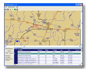
- Detailed visual map display, including street level data for the United States
- Drag and drop correction of georeferenced coordinates
- Polygon error determination
FAQs
1)Is there an easy way to record coordinates generated from user input mode into another program?Yes, right-click on the calculated coordinate you wish to copy and select copy to clipboard from the popup menu. You can then paste the number into another program or file.
2) Is there a way to select an entire column of data from the file input data screen and copy it to another program like excel?
Yes, right-click the column heading you with to copy and select copy to clipboard. Then open excel and paste the column of data into your spreadsheet.
3) Is it possible to measure distance on the map display?
Yes, hold down the shift key while you left-click and drag to make a straight line measurement in miles.
4) How do I pan the map display?
Hold down the ctrl key while you left-click and drag to pan across the map display.
5) How come TRS data appears to work for some localities and not others?
GEOLocate uses data from the TRS2LL program developed by Marty Wefald. Therefore GEOLocate can only calculate latitude and longitude from TRS data for the following states: AZ CA CO ID KS MT ND NE NM NV OK OR SD UT WA WY
6) How does GEOLocate compare with Biogemancer?
 To answer this,
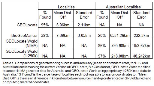
we randomly selected 100 unique hand-georeferenced locality records from
the TUMNH fish collection database. Each record was initially verified against digital
maps for accuracy of its coordinates. Inaccurate and non-continental records were
removed from the test dataset. The data were then georeferenced using GEOLocate
and Biogeomancer and the results were compared against the original hand-georeferenced
coordinates (Table 1). GEOLocate and Biogeomancer use similar gazetteer data for
the United States, but employ different georeferencing algorithms. GEOLocate also
supplements its core gazetteer with additional data such the river & road networks,
legal land descriptions and river miles. Both tools had comparable accuracy, as
indicated by the similar means and standard errors of distances between computed
and hand georeferenced coordinates. However, Biogeomancer was only able to georeference
39% of the records, whereas GEOLocate was able to use its additional data sources
to accurately georeference 95% of the records. Moreover, GEOLocate has the added
feature of allowing the user to visualize and adjust coordinates for all of its
determinations. An independent assessment of georeferencing tools published in 2004
also found GEOLocate to be the most accurate and efficient of computer-based georeferencing
solutions available at that time
(Murphey et al. 2004).
7) How can I represent locality uncertainty within GEOLocate?
The Standalone desktop application allows users to create polygons to define uncertainty for a given locality.
8) How do I cite the current version of GEOLocate?
Citation is shown below download link, near the bottom of this page. Click here to go straight there.
Features | Frequently Asked Questions | Updates | Downloads
Updates
3.21 August 19, 2010 (update available via autoupdate option)*- Improved usability of collaborative georeferencing interface.
- Added manual edit capability to collaborative georeferencing.
- Updated live maps link to bing maps.
- Added GEOLocate Web visualization.
- Added ability to restrict georeferencing to county orlower administrative unit.
- Added ability to define default map view extents on startup.
- Increased the total number of U.S. States where TRS can be found to 35 (click here for details).
- KML Export
- Misc. geocoder enhancements
- Added error handler to community datasource selector
3.11 February 5, 2009 (update available via autoupdate option)*
- Corrected problem with some multi-lingual displacements and/or patterns being incorectly identified.
- Added correction browser to collaborative georeferencing.
- Improved record selection for collaborative georeferencing.
- Added ability to skip records for collaborative georeferencing.
To update GEOLocate, select Help->Update GEOLocate->Check for Updates Now
from the main toolbar. Follow the onscreen instructions.
*requires version 2.03 or higher
3.0 October 14, 2008 (update available via autoupdate option)*
- Improved global georeferencing.
- Added collaborative georeferencing.
- Added multi-lingual georeferencing.
- Added link to maps.live.com.
- Added link to maps.google.com.
- Improved Georeferencing algorithm.
To update GEOLocate, select Help->Update GEOLocate->Check for Updates Now
from the main toolbar. Follow the onscreen instructions.
*requires version 2.03 or higher
2.13 June 6, 2005 (update available via autoupdate option)*
- Improved Georeferencing algorithm.
To update GEOLocate, select Help->Update GEOLocate->Check for Updates Now
from the main toolbar. Follow the onscreen instructions.
*requires version 2.03 or higher
2.12 May 22, 2005 (update available via autoupdate option)*
- Miscellaneous bug fixes.
To update GEOLocate, select Help->Update GEOLocate->Check for Updates Now
from the main toolbar. Follow the onscreen instructions.
*requires version 2.03 or higher
2.11 April 20, 2005 (update available via autoupdate option)*
-
Fixes a problem connecting to Microsoft Terraserver after a Terraservice update.
To update GEOLocate, select Help->Update GEOLocate->Check for Updates Now
from the main toolbar. Follow the onscreen instructions.
*requires version 2.03 or higher
2.1 April 8, 2005 (update available via autoupdate option)*
- Added support for enhanced visualization via Microsoft TerraServer - under the Display menu
-
New vizualization features include Aerial (USGS DOQ), Topo (USGS DRG), and USGS Urban Area
-
Added ability to save TerraServer maps as Jpegs
-
Added ability to correct results against TerraServer maps
To update GEOLocate, select Help->Update GEOLocate->Check for Updates Now
from the main toolbar. Follow the onscreen instructions.
*requires version 2.03 or higher
2.04 April 8, 2004 (update available via autoupdate option)*
-
Added ability to correct multiple selected rows in datagrid at once.
-
Added Full Extent, Zoom In, Zoom Out Buttons to toolbar.
-
Improved extents of full extent option on georeference options tab.
-
Changed some toolbar icons to more aesthetic versions.
-
Added Display Menu Item to Main Toolbar.
-
Added Scale Bar option to Display Menu - Displays Scale bar on map when checked.
-
Added File Save and Save As features for easier saving.
To update GEOLocate, select Help->Update GEOLocate->Check for Updates Now
from the main toolbar. Follow the onscreen instructions.
*requires version 2.03 or higher
2.03 Cumulative Update January 8, 2003 (click here to download)
-
Updates GEOLocate version from 2.0 (or 2.01/2.02) to 2.03.
-
Impoved detection of "best" point found among multiple results.
-
New menu item added under the help menu which integrates automatic Internet based updating.
To install, unzip the patch2_03.zip file to any directory on your hard drive and double-click the Patch2_03.exe file. Follow the onscreen instructions.
2.02 Cumulative Update December
3, 2003 (click here to download)
-
Updates GEOLocate version from 2.0 (or 2.01) to 2.02.
-
Corrected an issue where Yuma county would not display in the county picklist for Colorado.
-
Coordinates returned by geolocate are now rounded to 6 decimal places.
-
Increased accuracy of displacement calculations over large distances.
-
Map and data panes are now resizable.
To install, unzip the patch2_02.zip file to any directory on your hard drive and
double-click the Patch2_02.exe file. Follow the onscreen instructions.
2.01 Update September
22, 2003 (click here to download)
-
Updates GEOLocate version 2.0 to 2.01.
-
Corrects an issue regarding incorrect displacement calculations involving decimal numbers.
To install, unzip the patch2_01.zip file to any directory on your hard drive
and double-click the Patch2_01.exe file. Follow the onscreen instructions.
Features | Frequently Asked Questions | Updates | Downloads
Downloads
End User License Agreement. If you agree to the license agreement, click here to download GEOLocate (880 MB).
*You must update GEOLocate after downloading to get the latest version by clicking "Help->Updates->Check For Updates Now" from the program menu bar.
If you encounter any problems downloading & installing or prefer to recieve an installation CD set, please contact: Nelson Rios
How to cite:
-
Rios, N. E. & Bart, H. L. (2010). GEOLocate (Version 3.22)
  [Computer software]. Belle Chasse, LA: Tulane University Museum of Natural History.
Additional downloads & links:
Features | Frequently Asked Questions | Updates | Downloads

Web Application
Georeference collections data using your web browser. Quick and easy georeferencing.
Web Services
Integrate georeferencing into your own databases and applications using GEOLocate webservices.
Collaborative
Georeferencing
Build communities, share data, relate records across collections and improve verification efficiency.